📸🌲 بين 1969 و2026.. 57 عاماً تروي حكاية “الحيلونة” الجبلية
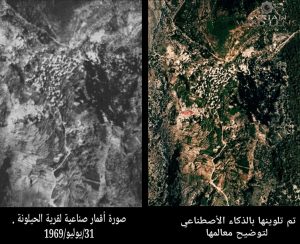
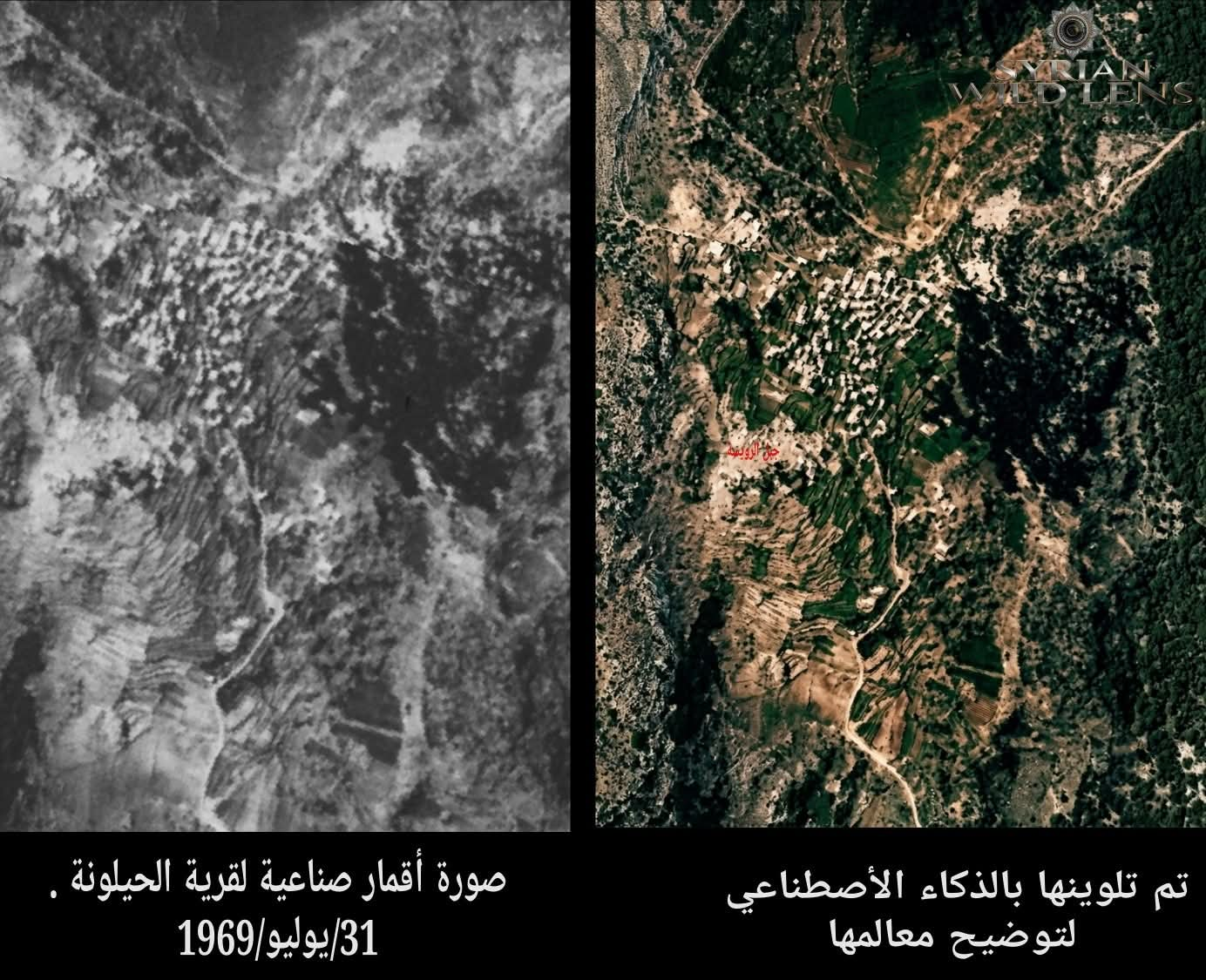
كمن يفتح نافذة عبر الزمن.. بعد قرابة ثلاثة أشهر من البحث المتواصل في الأرشيفات التاريخية والمواقع العالمية (من المعهد الفرنسي إلى وثائق جيش الشرق الأدنى وسلاح الجو الفرنسي)، نجحنا في منصة Syrian Wild Lens بالوصول إلى وثيقة بصرية نادرة لقرية الحيلونة (ريف مصياف) تعود لـ 31 يوليو 1969 عبر أرشيف أقمار التجسس الأمريكية القديمة (برنامج كورونا).
قمنا بإعادة تلوين هذه اللقطة التاريخية بالذكاء الاصطناعي لتتضح معالمها، ووضعناها في مقارنة مباشرة مع صور الأقمار الصناعية الحديثة للقرية. والفوارق تختصر حكاية أجيال.
🔍 ماذا تقول المقارنة؟
ما بين لقطة 1969 وصورة اليوم.. 57 عاماً من التحول العمراني والبيئي، تحكي قصة قرية لم تتوقف عن التغير.
🔸 التوسع العمراني المكثف:
في عام 1969، كان التجمع السكني محصوراً في نواة صغيرة متراصة (القرية القديمة)، ومنها ما وثقناه للحارة الشمالية التي ما زالت تحتفظ بذاكرتها وبنائها الحجري حتى اليوم.
أما اليوم، فقد تضاعفت الكتلة السكنية وامتدت طولاً وعرضاً، متسلقةً المنحدرات الجبلية، وظهرت أحياء جديدة بالكامل تحيط بالمركز القديم.
🔸 تغير النمط المعماري:
تحولت البيوت من النمط الريفي التقليدي (الذي كان يظهر عام 1969 ككتل متجانسة صغيرة، بأسقف طينية أو حجرية مستوية) إلى الأبنية الحديثة المتعددة الطوابق المصنوعة من البيتون المسلح، بأسطحها البيضاء والرمادية المحددة.
🔸 شبكة الطرق والمواصلات:
تظهر الخريطة الحديثة شبكة طرق معبدة وواضحة (مثل الطريق الملتوي الذي يمر بجانب مدرسة الحيلونة المحدثة والمبرة)، بينما كانت الطرق في 1969 مجرد ممرات ترابية ضيقة تعتمد على المشاة والدواب.
🔸 تنظيم وتراجع المدرجات الزراعية:
في 1969، كانت المدرجات الزراعية (المساكب الجبلية) تحيط بالقرية مباشرة وتكاد تلتصق بالبيوت كعصب أساسي للمعيشة.
أما اليوم، فقد زحف العمران فوق بعض هذه المدرجات، بينما تحول قسم آخر إلى حدائق منزلية، وتراجع قسم ثالث إلى أطراف القرية البعيدة، مع تحول بعض الأراضي إلى أحراج أو غطاء نباتي أكثر كثافة نتيجة لتغير النشاط الاقتصادي للأهالي.
🌿 من الحارة الشمالية.. إلى الذالمن يرغب في العودة إلى تفاصيل الحارة الشمالية في الحيلونة، بصورها ومعلوماتها التي وثقناها سابقاً، يمكنكم زيارة الرابط التالي:
❓ والسؤال الآن:
هل تعرفون قرية تحولت ملامحها عبر الزمن كما تحولت الحيلونة؟ وهل لديكم صور قديمة تحكي حكاية قريتكم؟
شاركونا.. فكل صورة قديمة هي وثيقة، وكل ذكرى هي جزء من الذاكرة.
🌿 رسالتنا.. ورسالتكم
في Syrian Wild Lens، نؤمن أن توثيق الحاضر وحفظ الماضي ليس مجرد هواية، بل هي رسالة نسعى من خلالها لترك بصمة حقيقية للأجيال القادمة، ليتعرفوا على تاريخ قراهم، وجذور أجدادهم، والقصص التي خُبئت في تفاصيل هذه الأرض المعطاءة.
لأن تاريخ قراكم يهمنا.. نفتح لكم صندوق رسائل الصفحة؛ فكل من يرغب في البحث والتقصي عن تاريخ قريته، أو الحصول على صور جوية ووثائق قديمة لبلدته، ما عليه إلا أن يراسلنا. نحن جاهزون دائماً لتلبية طلباتكم والبحث معكم في خبايا الأرشيف التاريخي! 📬✨
📸 من أرشيف Syrian Wild Lens
🚀 الرحلة مستمرة… إذا كنت تعشق أسرار السماء وتراث الأرض، اضغط على زر “متابعة” لتكون معنا في التوثيق القادم لـ Syrian Wild Lens. 🌿📸
📸🌲 Between 1969 and 2026.. 57 Years Tell the Story of “Al-Helouneh”
Like opening a window through time.. after about three months of continuous research in historical archives and global websites (from the French Institute to the documents of the Army of the Levant and the French Air Force), we at Syrian Wild Lens succeeded in reaching a rare visual document of Al-Helouneh village (Misyaf’s countryside) dating back to July 31, 1969, through the archive of old American spy satellites (Corona Program).
We re-colored this historical snapshot using AI to clarify its features, and placed it in a direct comparison with modern satellite images of the village. The differences summarize the story of generations.
🔍 What Does the Comparison Say?
Between the 1969 snapshot and today’s image.. 57 years of urban and environmental transformation, telling the story of a village that never stopped changing.
🔸 Intensive Urban Expansion:
In 1969, the residential cluster was confined to a small compact core (the old village), including what we documented of the Northern Quarter that still retains its memory and stone architecture today.
Today, the residential mass has multiplied and extended lengthwise and widthwise, climbing the mountain slopes, with entirely new neighborhoods surrounding the old center.
🔸 Change in Architectural Style:
Houses transformed from the traditional rural style (which appeared in 1969 as small homogeneous blocks, often with flat mud or stone roofs) to modern multi-story buildings made of reinforced concrete, with their distinct white and gray roofs.
🔸 Road and Transportation Network:
The modern map shows a clear paved road network (such as the winding road passing beside the modern Al-Helouneh School and Al-Mabarra), while in 1969 the roads were just narrow dirt paths dependent on pedestrians and animals.
🔸 Organization and Decline of Agricultural Terraces:
In 1969, agricultural terraces (mountainous slopes) surrounded the village directly and almost clung to the houses as the backbone of livelihood.
Today, urbanization has crept over some of these terraces, while another part has turned into home gardens, and a third has retreated to the far edges of the village, with some lands turning into woodlands or denser vegetation due to the change in residents’ economic activity.
🌿 From the Northern Quarter.. to Memory
For those who wish to return to the details of the Northern Quarter in Al-Helouneh, with its images and information we previously documented, you can visit the following link:
🔗 https://www.facebook.com/share/19FyNhVxuA/
❓ And the Question Now:
Do you know a village whose features changed over time as Al-Helouneh did? Do you have old photos that tell the story of your village?
Share with us.. for every old photo is a document, and every memory is part of the memory.
🌿 Our Message.. and Yours
At Syrian Wild Lens, we believe that documenting the present and preserving the past is not just a hobby, but a message through which we seek to leave a real mark for future generations, so they can learn about the history of their villages, the roots of their ancestors, and the stories hidden in the details of this giving land.
Because the history of your villages matters to us.. we open our page’s message box for you; anyone who wishes to research and investigate the history of their village, or obtain aerial photos and old documents of their town, can simply message us. We are always ready to fulfill your requests and search with you in the depths of historical archives! 📬✨
📸 From the archive of Syrian Wild Lens
🚀 The journey continues… If you love the secrets of the sky and the heritage of the land, hit “Follow” to join us in the next documentation by Syrian Wild Lens. 🌿📸
#الحيلونة #مصياف #أرشيف_كورونا #صور_جوية #تاريخ_القرى #الذاكرة #التوثيق #SyrianWildLens #AlHelouneh #Misyaf #CoronaArchive #AerialPhotos #VillageHistory #Memory #Documentation #SyrianHeritage #SyrianHistory #SyrianVillages #UrbanTransformation #1969 #2026 #SyrianNature #Archives #HistoricalPhotos #SyrianLandscapeم٠لة ايليت فوتو ارت.