🌊 بين الأسطورة والحقيقة العلمية… ماذا كان يعيش في سهل الغاب قبل التجفيف؟
يُشكل “سهل الغاب” في الذاكرة البيئية السورية واحداً من أغرب وأجمل الأنظمة المائية البرية التي عرفها الشرق الأوسط قبل تجفيفه في خمسينيات القرن الماضي.
حوض مائي هائل امتد على طول ٨٠ كم، تحكمت فيه فيضانات نهر العاصي، ليصنع محمية طبيعية ساحرة ومستنقعاً ضخماً عجّ بالحياة والغموض.
ومؤخراً… يتردد سؤال بكثرة بين محبي الحياة البرية:
هل كانت التماسيح تعيش في مستنقعات سهل الغاب؟
في هذا التوثيق من Syrian Wild Lens، نغوص معكم عبر الجيولوجيا، والتاريخ، والهندسة… لقطع الشك باليقين. 🗺️🦅
🐊 أولاً: قصة “التماسيح” في الغاب… أسطورة أم حقيقة؟
بشكل قاطع وعلمي: لم يثبت أي وجود لحيوان التمساح الحقيقي في سهل الغاب أو نهر العاصي في التاريخ الحديث.
إذاً… من أين يأتي هذا اللبس؟
🔸 مصيدة البحث الرقمي: عند البحث في “جوجل”، تظهر نصوص توثق وجود تماسيح في بلاد الشام. لكن هذا الوجود كان محصوراً تاريخياً في جنوب بلاد الشام (نهر الزرقاء في الأردن، ونهر التماسيح في فلسطين)، ولم يمتد نطاقها البيئي شمالاً إلى سوريا.
🔸 الخلط مع “الورل المائي السوري”: التمساح الحقيقي لم يعش هناك، لكن كان هناك “ملك المستنقعات” وهو الورل المائي. هذا الزاحف الضخم كان ينمو ليتجاوز طوله المتر والنصف، ويمتلك جلداً حراشفياً وبنية تشبه التمساح تماماً عند السباحة. السكان المحليون والجغرافيون القدامى (مثل ابن الوردي في كتابه “خريدة العجائب وفريدة الغرائب”) كانوا يطلقون عليه مجازاً “التمساح الأصغر”.
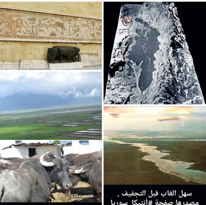
🔸 غياب التوثيق الأثري: مدينة “أفاميا” الأثرية المطلة على السهل اشتهرت بأكبر لوحات الفسيفساء في العالم. وثّق الفنان السوري القديم كل تفاصيل الحياة البرية (الأسود، النمور، الدببة، الخنازير، الطيور، والأسماك)… ولم ترسم لوحة واحدة تمساحاً.
🐗 ثانياً: من هم السكان الأصليون لسهل الغاب؟
إذا غبنا عن التماسيح، فإن الغاب كان يعج بمملكة حيوانية مذهلة اختفت أو تراجعت بعد التجفيف:
🔸 الجاموس المائي السوري: القطعان الهائلة التي كانت تقضي يومها غارقة في المياه والوحل، وتتغذى على البردي.
🔸 الخنازير البرية الضخمة: التي كانت تتخذ من غابات القصب والبردي ملجأً.
🔸 مملكة الأسماك النادرة: وخاصة “السمك الأسود السوري” وثعابين الماء (الحنكليس).
🔸 المطار العالمي للطيور: كان الغاب أهم محطة في الشرق الأوسط لهجرة الطيور بين أوروبا وأفريقيا، حيث كانت تلتجئ إليه ملايين البجع واللقالق والبط البري.
⛏️ ثالثاً: الملحمة الهندسية وقهر الجدار البازلتي (١٩٥٢ – ١٩٥٦)
كيف تحول هذا المستنقع الأسطوري إلى أرض زراعية؟ لم يكن الأمر سهلاً… بل تطلب معركة هندسية حقيقية ضد الطبيعة.
🔸 المعضلة: كان سبب غرق السهل هو وجود “عتبة صخرية بازلتية” شديدة القساوة عند منطقة (مضيق القرقور وشيزر). هذه العتبة كانت تعمل كـ”سد طبيعي” يحجز مياه نهر العاصي ويردها للخلف.
🔸 الحل الهندسي: في عام ١٩٥٢، جُلبت آلات حفر هيدروليكية عملاقة، وتم ثقب الجدار البازلتي الصلب عبر شبكة حفر دقيقة، وحُشيت بأطنان من الديناميت.
🔸 النسف والتجفيف: عبر تفجيرات متسلسلة ومدروسة، تم تفتيت العتبة الصخرية، لتندفع المياه المتراكمة لآلاف السنين -بفعل الجاذبية- نحو الشمال لأول مرة. ترافق ذلك مع حفر ونقل ١٢ مليون متر مكعب من الأتربة والصخور، وشق قنوات بيتونية عملاقة، ليتحول الغاب إلى أخصب ٢٥ ألف هكتار زراعي في سوريا.
🍂 رابعاً: الصدمة البيئية والمناخية للحاضر
رغم أن التجفيف أنقذ المنطقة من الملاريا والأوبئة ووفّر سلة غذائية كبرى… إلا أن البيئة دفعت ثمناً قاسياً نعيشه اليوم:
🔸 التطرف المناخي: اختفاء المسطح المائي الضخم أفقد المنطقة “المنظم الحراري الطبيعي”. ارتفعت درجات الحرارة صيفاً، وزاد الصقيع شتاءً، وجفت الرطوبة الجوية المحيطة.
🔸 تغير مسارات الطيور: فقدت الطيور المهاجرة ملاذها الآمن، مما غيّر من خريطة الهجرة العالمية عبر سوريا.
🔸 حرائق التربة التوربية الكامنة: تحللت النباتات المائية عبر آلاف السنين لتصنع تربة “التورب” العضوية، والتي أصبحت بعد تجفيفها قابلة للاشتعال الذاتي تحت الأرض عند درجات الحرارة المرتفعة، وهي من أغرب الظواهر البيئية في السهل.
📸 مصادر الصور:
🔸 مجسم قديم لسهل الغاب قبل التجفيف (الصورة من الشمال باتجاه الجنوب) — من صفحة جبال سوريا الاجتماعية.
🔸 سهل الغاب قبل التجفيف — من صفحة أنتيكا سوريا.
🔸 فسيفساء أرضية من المتحف الوطني بدمشق، مكتشفة في منطقة أفاميا بأطراف سهل الغاب، وتظهر رسومات دقيقة للطيور والحيوانات الصغيرة التي كانت تعيش في السهل بالقرن الخامس الميلادي.
🔸 كيف أصبح سهل الغاب أراضي زراعية — من موقع مونت كارلو الدولية.
📸 من أرشيف Syrian Wild Lens
❓ هل سمعتم عن سهل الغاب قبل التجفيف؟ وهل تعرفون حكايات عن تلك الحقبة؟ شاركونا… فالحكاية لم تنتهِ بعد. 🌊🌿
🚀 الرحلة مستمرة… إذا كنت تعشق أسرار السماء وتراث الأرض، اضغط على زر “متابعة” لتكون معنا في التوثيق القادم لـ Syrian Wild Lens. 🌿📸
🌊 Between Legend and Scientific Truth… What Lived in the Ghab Plain Before Drying?
The “Ghab Plain” in Syrian environmental memory is one of the strangest and most beautiful aquatic ecosystems the Middle East knew before its drying in the 1950s.
A vast water basin extending 80 km, controlled by Orontes River floods, creating an enchanting natural reserve and a huge marsh teeming with life and mystery.
Recently… a question is frequently circulated among wildlife lovers:
Did crocodiles live in the Ghab Plain marshes?
In this documentation from Syrian Wild Lens, we dive through geology, history, and engineering… to settle the doubt with certainty. 🗺️🦅
🐊 First: The Story of “Crocodiles” in the Ghab… Myth or Truth?
Definitively and scientifically: No real crocodile presence has been proven in the Ghab Plain or the Orontes River in modern history.
So… where does this confusion come from?
🔸 Digital Search Trap: When searching on “Google,” texts documenting crocodile presence in the Levant appear. But this presence was historically confined to the southern Levant (Zarqa River in Jordan, and Crocodile River in Palestine), and its ecological range never extended north to Syria.
🔸 Confusion with the “Syrian Water Monitor”: The real crocodile did not live there, but there was the “King of the Marshes”, the water monitor. This large reptile grew to exceed 1.5 meters in length, with scaly skin and a structure resembling a crocodile when swimming. Locals and ancient geographers (like Ibn al-Wardi in his book “Kharidat al-Aja’ib wa Faridat al-Ghara’ib”) called it metaphorically “The Smaller Crocodile”.
🔸 Absence of Archaeological Documentation: The ancient city of “Apamea” overlooking the plain was famous for the largest mosaics in the world. The ancient Syrian artist documented every detail of wildlife (lions, leopards, bears, boars, birds, and fish)… and not a single mosaic depicted a crocodile.
🐗 Second: Who Were the Original Inhabitants of the Ghab Plain?
If we set aside crocodiles, the Ghab was teeming with an amazing animal kingdom that disappeared or declined after drying:
🔸 Syrian Water Buffalo: Huge herds that spent their day submerged in water and mud, feeding on papyrus.
🔸 Large Wild Boars: Which took refuge in the dense reed and papyrus forests.
🔸 Kingdom of Rare Fish: Especially the “Syrian Black Fish” and water snakes (eel).
🔸 Global Bird Airport: The Ghab was the most important station in the Middle East for bird migration between Europe and Africa, where millions of pelicans, storks, and wild ducks sought refuge.
⛏️ Third: The Engineering Epic and Conquering the Basalt Wall (1952 – 1956)
How did this legendary marsh turn into agricultural land? It was not easy… but required a real engineering battle against nature.
🔸 The Dilemma: The cause of the plain’s flooding was a “basalt rock sill” of extreme hardness at the Qarqour and Sheizar strait area. This sill acted as a “natural dam” holding back the Orontes River waters and pushing them back.
🔸 The Engineering Solution: In 1952, giant hydraulic drilling machines were brought, and the solid basalt wall was drilled through a precise network of holes, filled with tons of dynamite.
🔸 Blasting and Drying: Through sequential and studied explosions, the rock sill was shattered, allowing water accumulated for thousands of years to rush northward – by gravity – for the first time. This was accompanied by moving 12 million cubic meters of soil and rocks, and digging giant concrete channels, transforming the Ghab into the most fertile 25,000 hectares of agricultural land in Syria.
🍂 Fourth: The Environmental and Climatic Shock of the Present
Although drying saved the region from malaria and epidemics and provided a major food basket… the environment paid a heavy price we live today:
🔸 Climate Extremes: The disappearance of the vast water surface deprived the region of its “natural thermal regulator”. Temperatures rose in summer, frost increased in winter, and atmospheric humidity dried up in the surrounding areas.
🔸 Changing Bird Migration Routes: Migratory birds lost their safe haven, changing the global migration map through Syria.
🔸 Latent Peat Soil Fires: Aquatic plants decomposed over thousands of years to create organic “peat” soil, which after drying became self-ignitable underground at high temperatures, one of the strangest environmental phenomena in the plain.
📸 Image Sources:
🔸 Old model of the Ghab Plain before drying (view from north to south) — from Syria’s Mountains Social page.
🔸 Ghab Plain before drying — from Antika Syria page.
🔸 Floor mosaic from the National Museum in Damascus, discovered in the Apamea area on the edges of the Ghab Plain, showing precise drawings of birds and small animals that lived in the plain in the 5th century AD.
🔸 How the Ghab Plain became agricultural land — from Monte Carlo International website.
📸 From the archive of Syrian Wild Lens
❓ Have you heard of the Ghab Plain before drying? Do you know stories from that era? Share with us… for the tale is not over yet. 🌊🌿
🚀 The journey continues… If you love the secrets of the sky and the heritage of the land, hit “Follow” to join us in the next documentation by Syrian Wild Lens. 🌿📸
#سهل_الغاب #نهر_العاصي #التماسيح #الورل_المائي #الجاموس_المائي #التجفيف #الملاريا #الطيور_المهاجرة #أفاميا #الفسيفساء #ابن_الوردي #خريدة_العجائب #SyrianWildLens #GhabPlain #OrontesRiver #Crocodiles #WaterMonitor #WaterBuffalo #Drying #Malaria #MigratoryBirds #Apamea #Mosaics #IbnAlWardi #KharidatAlAjaib #SyrianHeritage #SyrianHistory #EnvironmentalHistory #Biodiversity #Conservation #Wetlands #MiddleEastNature #SyrianVillages #AgriculturalHeritage٠مجلة ايليت فوتو ارت.