*** تراثيات قرى سورية ؛؛؛ #حيالين* #الزينة * #الحريف ***
#هكذا #جاء #في #المنشور
###📸 #كنز #من #السماء… حين صوّرت الطائرات الفرنسية قرى مصياف قبل ١٠٠ عام
في عام ١٩٢٦، وقبل قرن كامل من اليوم…
حلّقت طائرة استطلاع فرنسية فوق جبال ريف مصياف الغربي. لم تكن تحمل مسافرين… بل كاميرا.
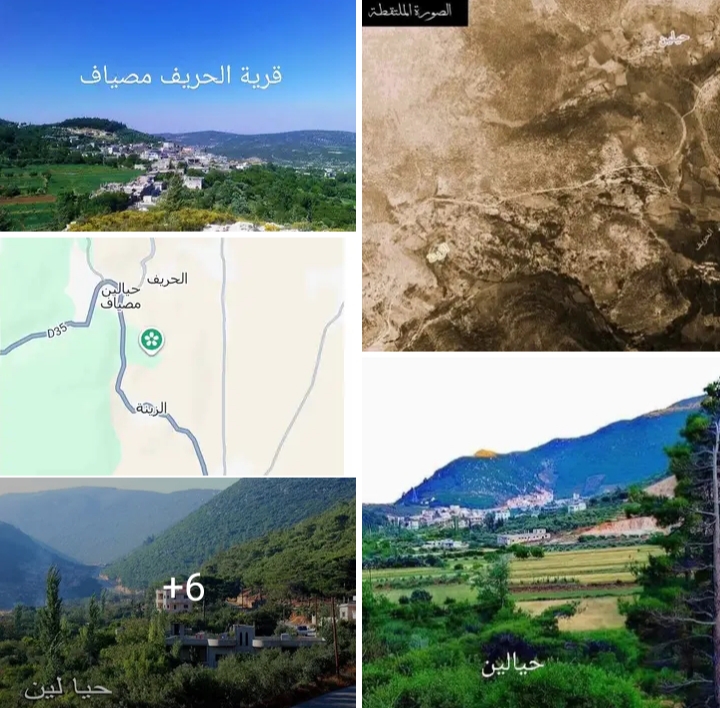
ومن علٍ، التقطت لقطة جوية نادرة وعالية الدقة لثلاث قرى:
🔸 حيالين — في الزاوية العلوية اليمنى.
🔸 الزينة — في الجهة اليسرى المتوسطة.
🔸 الحريف — في الجهة اليمينية السفلية.
🛩️ لماذا كانت هذه الطائرات في سماء سوريا؟
في عام ١٩٢٦، كان سلاح الجو الفرنسي (جيش الشرق) يمتلك أسراباً من الطائرات في سوريا، متمركزة في مطارات مثل المزة بدمشق، وحلب، ودير الزور.
واستخدمت هذه الطائرات لثلاثة أهداف أساسية:
🔸 الاستطلاع العسكري: لرصد تحركات الثوار السوريين في الجبال والصحراء.
🔸 رسم الخرائط: اعتمد “المكتب الطبوغرافي لجيش الشرق” على الصور الجوية لتحديث الخرائط الجغرافية بدقة متناهية.
🔸 علم الآثار الجوي: وهو علم رائد في سوريا، حيث قام الطيار والباحث الفرنسي “أنطوان بويدبار” برحلات جوية وتصوير آلاف الصور لصحراء الشام، مكتشفاً مواقع أثرية وقلاعاً رومانية مدفونة لم يكن ممكناً رؤيتها من الأرض.
🔍 ما الذي تكشفه الصورة؟
🔸 طبيعة الغطاء النباتي والزراعي: تظهر بوضوح “الجلول” والتقسيمات الحقلية المربعة والصغيرة المحيطة بالقرى، وهي الطريقة التقليدية التي كان يعتمدها أهالي الجبال في استصلاح الأراضي الوعرة آنذاك.
🔸 شح الكتلة العمرانية: نلاحظ تفككاً كبيراً في المنازل، وندرة في الأبنية المتصلة، حيث كانت القرى تقتصر على بضع حارات من البيوت الطينية والحجرية القديمة المتجمعة حول عيون الماء والمناطق الأكثر أماناً، قبل التوسع العمراني الضخم الذي شهدته المنطقة في العقود الأخيرة.
🔸 الطرق والمسالك: يظهر ممر شبه خطي متعرج يخترق الجبل، يربط بين هذه البلدات، وهو يمثل المسالك الجبلية القديمة التي كانت تسلكها الدواب والمشاة قبل تعبيد الطرق الحديثة.
🏛️ أين تُحفظ هذه الكنوز؟
الصورة التي وصلتنا تنتمي بنسبة كبيرة إلى إحدى جهتین في الأرشيف الفرنسي:
🔸 أرشيف المعهد الفرنسي للشرق الأدنى (IFPO): يضم القسم الأكبر من المجموعات الفوتوغرافية النادرة التي التقطها الجيش الفرنسي. منذ عام ١٩٢٥، ركّز سلاح الجو الفرنسي على تصوير منطقة مصياف، والقدموس، ووادي العيون نظراً لأهميتها الاستراتيجية.
🔸 أرشيف الأب “أنطوان بويدبار” (Antoine Poidebard): رائد التصوير الجوي الأثري في العالم، بدأ رحلاته الجوية في سوريا في مايو ١٩٢٥ واستمر خلال ١٩٢٦ بالتعاون مع سلاح الجو الفرنسي. وثّق ريف حماة الغربي وجبال الساحل لتتبع الحصون الرومانية والبيزنطية. أرشيفه محفوظ اليوم بين المكتبة الشرقية لجامعة القديس يوسف في بيروت، ومنظمة MOM (دار الشرق والمتوسط في ليون).
🌿 تأمل…
قبل ١٠٠ عام، كانت هذه القرى تبدو بضع حارات متفرقة، وبيوتاً متواضعة، ومسالك ضيقة…
واليوم، هي #قرى #عامرة، وطرقات معبدة، وأجيال تتوارث الحكاية.
الزمن يمر… لكن الذاكرة تبقى.
📸 المصدر: الأرشيف الرقمي لسلاح الجو الفرنسي (جيش الشرق)
🙏 شكراً للأخ والصديق مازن أحمد أبو طالب على مشاركتنا هذه الصورة النادرة.
❓ هل تعلمون أن قرى مصياف وُثّقت من الجو قبل ١٠٠ عام؟ وهل لديكم صور قديمة مشابهة؟ شاركونا… فالحكاية لم تنتهِ بعد. 🌿🏔️
🚀 الرحلة مستمرة… إذا كنت تعشق أسرار السماء وتراث الأرض، اضغط على زر “متابعة” لتكون معنا في التوثيق القادم لـ Syrian Wild Lens. 🌿📸
📸 A Treasure from the Sky… When French Planes Photographed Misyaf’s Villages 100 Years Ago
In 1926, a full century before today…
A French reconnaissance plane flew over the mountains of Misyaf’s western countryside.
It carried no passengers… only a camera.
And from above, it captured a rare, high-resolution aerial shot of three villages:
🔸 Hayalin — in the upper right corner.
🔸 Al-Zayna — in the middle left.
🔸 Al-Harif — in the lower right.
🛩️ Why Were These Planes in Syria’s Skies?
In 1926, the French Air Force (Army of the Levant) had squadrons stationed in Syria, based at airports such as Mezzeh in Damascus, Aleppo, and Deir ez-Zor.
These planes were used for three main purposes:
🔸 Military Reconnaissance: To monitor the movements of Syrian revolutionaries in the mountains and desert.
🔸 Map Making: The “Topographic Bureau of the Army of the Levant” relied on aerial photos to update geographic maps with extreme precision.
🔸 Aerial Archaeology: A pioneering science in Syria, where French pilot and researcher Antoine Poidebard conducted aerial trips and photographed thousands of images of the Syrian desert, discovering archaeological sites and buried Roman castles invisible from the ground.
🔍 What Does the Photo Reveal?
🔸 Nature of Vegetation and Agriculture: The “Jaloul” and small square field divisions around the villages (especially around Hayalin) are clearly visible, reflecting the traditional method used by mountain people to reclaim rugged land.
🔸 Sparse Urban Mass: We notice a significant dispersion of houses and a scarcity of connected buildings, as villages were limited to a few neighborhoods of old mud and stone houses clustered around water springs and safer areas, before the massive urban expansion witnessed in recent decades.
🔸 Roads and Paths: A semi-linear winding passage cutting through the mountain appears, linking these towns. It represents the ancient mountain paths used by animals and pedestrians before modern roads were paved.
🏛️ Where Are These Treasures Kept?
The photo we received most likely belongs to one of two entities in the French archive:
🔸 Archive of the French Institute of the Near East (IFPO): Holds the largest collection of rare photographic groups taken by the French Army. Since 1925, the French Air Force focused on photographing the Misyaf, Al-Qadmous, and Wadi Al-Oyoun areas due to their strategic importance.
🔸 Archive of Father “Antoine Poidebard”: The world pioneer of aerial archaeological photography, who began his aerial trips in Syria in May 1925 and continued through 1926 in cooperation with the French Air Force. He documented the western Hama countryside and coastal mountains to trace Roman and Byzantine fortresses. His archive is preserved today between the Oriental Library of Saint Joseph University in Beirut and the MOM organization (House of the Orient and Mediterranean in Lyon).
🌿 A Reflection…
100 years ago, these villages looked like a few scattered neighborhoods, humble houses, and narrow paths…
Today, they are thriving villages, paved roads, and generations inheriting the tale.
Time passes… but memory remains.
📸 Source: Digital Archive of the French Air Force (Army of the Levant)
🙏 Thanks to our friend Mazen Ahmad Abu Taleb for sharing this rare photo with us.
❓ Did you know Misyaf’s villages were documented from the air 100 years ago? Do you have similar old photos? Share with us… for the tale is not over yet. 🌿🏔️
🚀 The journey continues… If you love the secrets of the sky and the heritage of the land, hit “Follow” to join us in the next documentation by Syrian Wild Lens. 🌿📸
#مصياف #حيالين #الزينة #الحريف #التصوير_الجوي #الأرشيف_الفرنسي #١٩٢٦ #التراث #التوثيق #SyrianWildLens #Misyaf #Hayalin #AlZayna #AlHarif #AerialPhotography #FrenchArchive #1926 #مجلة ايليت فوتو ارت